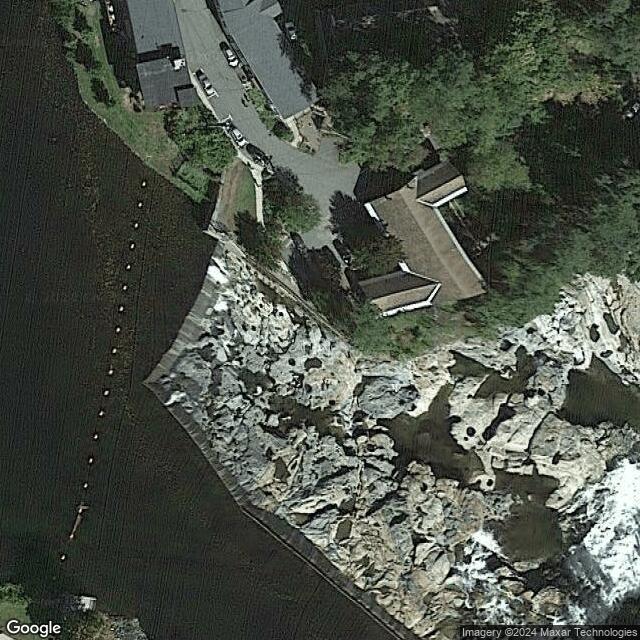
Shelburne Falls Potholes MA
Motorcyclist Map
Places Filter: Oddities, Landscapes
View In Google Maps: https://goo.gl/maps/fL3VfyshaFp8Exrw5
Description: The Shelburne Falls Potholes, located in the village of Shelburne Falls, Massachusetts, is a natural wonder created by the glacial forces that shaped the landscape thousands of years ago. Carved into the bedrock of the Deerfield River, the potholes are a series of cylindrical basins and swirling eddies that form as the rushing water erodes the rock over time. These potholes range in size from small, shallow depressions to larger, deeper basins, some of which can measure several feet in diameter and depth. The swirling currents and abrasive action of the river's sediment-filled waters have sculpted the smooth, circular shapes of the potholes, creating a mesmerizing and otherworldly landscape. Visitors to Shelburne Falls can access the potholes via a short hike along the riverbank, where they can marvel at the natural beauty and geological features of the area. In the warmer months, adventurous visitors may even take a refreshing dip in the cool, clear waters of the potholes, although caution is advised due to the unpredictable nature of the currents and the slippery rocks. In addition to the potholes themselves, Shelburne Falls is also home to the historic Bridge of Flowers, a charming pedestrian bridge adorned with vibrant floral displays, as well as a variety of shops, galleries, and restaurants that showcase the village's artistic and cultural heritage.