Manara Cliff - Upper to Metula
Motorcyclist Map
Route Suggested By: Helio Diamant - https://diamant.org.il/blog
View In Google Maps: https://maps.app.goo.gl/kYe7vbkVLckyxMAK9
GPX Download: https://drive.google.com/file/d/1tKt95Cs5mq0IcFLiBVkmczA2euBiYiFj/view?usp=sharing
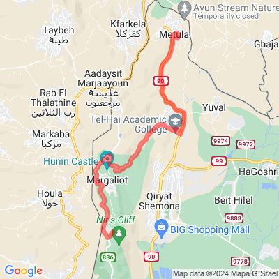
Description: After finishing at Manara Cliff, our next stop will be nearby, at Metula. Metula will probably be your sleeping point for continuing in the next day (or days - two nights in Metula isn't something one would regret). Getting there is not complicated and doesn't take time. Metula is a town located some 10 minutes to the North of Kiryat Shemona and at the very North border of Israel with Lebanon - the nail of the Galilee Finger. Once per year there is a motorcycle weekend in Metula, with a big crowd of motorcycles arriving there. A visit to the reserve of Ayun River is a necessary visit. It is a canyon with 4 waterfalls including the famous (in Israel) Tanur waterfall and Ayun waterfall. Reserve around 1 hour for a walk there. You don't need to get out of Metula to get there, there is an entrance to the canyon from one of the streets in the village, and the whole visit can be done on foot. But Metula has much more to do from a tour of the Lebanese border organized by locals there, through a visit to Canada Center, a kind of a country club with pools, bowling and ice skating, and up to good restaurants for meat and pizza, there is always something good to do in this small village. And if this is not enough, you can travel some kilometers to the east and do some nice rafting at the Banias river, one of the sources of the Jordan River. It is easy to see how to get to Metula with the map below.
Admin Country: Israel